The Santa Fe Railyard is yet another prime example of the adaptive reuse and redesign of land for a public space purpose. Born in the 2000s, the park is among the growing movement of turning underused or contaminated land into park space. In this example, the heart of downtown Santa Fe has been re-energized by the implementation of the park. It successfully connects neighborhoods that had previously been discouraged in doing so by the blighted site. A light industrial site that was all but abandoned is now a green and scenic space that promotes the health and quality of life of the citizens of the city.
The park is exactly what its name suggests. It is a transformation of the former Santa Fe Railyard, which was an active hub in this outpost of the mountain west during the era of train dominance. However, that dominance began to wane dramatically in the mid 20th century as the importance of interstate automobile transport elevated. Before that, however, the railyard was a central hub of life in Santa Fe. It was a terminal and was an important stop for both freight and tourists alike. The neighborhoods directly surrounding the yard grew dramatically as a direct result of its presence, due to the demand of housing the workers associated with the rail economy. As the importance of rail declined, the site deteriorated along with the surrounding neighborhoods.
A large public and private partnership initiated a move for change in a new direction for the site throughout the 1990s and 2000s. The Trust for Public Land helped to design the resulting park, which came about through a Master Plan that was developed with thorough public input. The citizens of Santa Fe wished to create a site that integrated the unique history, landscape, and culture of the region while turning it into the central hub it had once been. The park is now operated by the Santa Fe Railyard Community Corporation, a non-profit organization, once again signifying the importance of public-private partnerships in creating successful public spaces. This process resulted in a sustainable public space that opened in 2008 and provides trails, art, and communal space that spans over a 13 acre parcel. It is a true mix between an recreation open space and a well-designed and built cultural attraction. As an example, trails go right up against old parked rail cars that are adorned with artwork and provide character to the new hub that has been created. The park also provides a sustainable oasis, as innovative practices in the storage, harvesting, and distribution of water have been implemented, resulting in vegetation that flourishes in an otherwise arid and often drought-stricken region.
Santa Fe has historically been an independent city with its own sense of culture, and has long attracted artistic types. The Railyard is certainly a welcome addition to this setting and has quickly gained rave reviews and become a focal attraction within the city. It is also a model for other cities to follow in redeveloping underused or abandoned sites for public parkland. This relatively small parcel of land in Santa Fe has had a great positive impact within the city due this process.
Tuesday, April 23, 2013

Monday, April 22, 2013
High Line - New York, NY
The High Line has quickly established itself as one of the most popular park in New York City, despite the fact that is among the newest. It has also quickly become a celebrated example for other cities and projects to follow as it showcases the tremendous positive potential of parks and their impact on the surrounding community. Above all, the park turned a blighted and abandoned stretch of land into an incredible resource and attraction. It achieved this by adaptively reusing a a former elevated rail line into a publicly accessible and environmentally-friendly green space.
The park is the result of a recycling of a former elevated rail line that went right through the Meatpacking District and Chelsea south of Penn Station on the west side of Manhattan. From 1934 until 1980, an industrial freight train line existed on the same path on which the park now stands. It served as a connection between Midtown and Lower Manhattan for factories and warehouses. It rolled directly through dense development, and alarmingly close to buildings. It even connected directly inside of some buildings and factories, such as Chelsea market. It was viewed useful ploy to alleviate street traffic by allowing goods and produce to be unloaded without disturbing the flow of traffic. However, the usefulness of the line declined in the 1950s as the dominance of interstate trucking began to take hold. In 1960, the southernmost section of the line was demolished, which was about half of its length. By 1980, all train traffic ceased on the remaining section. However, the elevated line continued to exist in abandonment.
The abandoned and quickly overgrown rail line cut through a gritty area of Manhattan. The rail line served as a metaphor for an area with declining industry and a rough reputation. However, by 1999, a non-profit group called Friends of the High Line, started a campaign to preserve and renovate the line as it was being slated for demolition. They advocated for the reuse of the line for green space or park purposes. By 2004, Mayor Michael Bloomberg had thrown his support towards the project and it was on its way. By 2009, the southern section of the park was opened, and it was followed by the northern section in 2011. The resulting park is a leisurely, and at times narrow, 1.45 mile pedestrian walkway above the streets of Chelsea. Public seating has been provided throughout its length and it is interspersed with well-designed landscaping that add to the incredible views of the city and the Hudson River.
The High Line has also had an enormously positive economic development impact on its surrounding neighborhood. It has increased foot traffic to the area, as it has become a favored local and tourist destination due to its free and public nature. New businesses and residential developments have also spouted up as a result. Chelsea and the surrounding area have become home to a young and fashionable crowd, and rents and real estate prices have skyrocketed. Luxury units are now commonplace along the sides of the park, with only feet separating their respective boundaries. The success of the High Line has spurred a slate of similar plans and ideas in cities across the world for transforming abandoned elevated land into public space. The park proves that antiquated land uses can be transformed into modern public amenities that substantially improve neighborhood quality of life.
The park is the result of a recycling of a former elevated rail line that went right through the Meatpacking District and Chelsea south of Penn Station on the west side of Manhattan. From 1934 until 1980, an industrial freight train line existed on the same path on which the park now stands. It served as a connection between Midtown and Lower Manhattan for factories and warehouses. It rolled directly through dense development, and alarmingly close to buildings. It even connected directly inside of some buildings and factories, such as Chelsea market. It was viewed useful ploy to alleviate street traffic by allowing goods and produce to be unloaded without disturbing the flow of traffic. However, the usefulness of the line declined in the 1950s as the dominance of interstate trucking began to take hold. In 1960, the southernmost section of the line was demolished, which was about half of its length. By 1980, all train traffic ceased on the remaining section. However, the elevated line continued to exist in abandonment.
The abandoned and quickly overgrown rail line cut through a gritty area of Manhattan. The rail line served as a metaphor for an area with declining industry and a rough reputation. However, by 1999, a non-profit group called Friends of the High Line, started a campaign to preserve and renovate the line as it was being slated for demolition. They advocated for the reuse of the line for green space or park purposes. By 2004, Mayor Michael Bloomberg had thrown his support towards the project and it was on its way. By 2009, the southern section of the park was opened, and it was followed by the northern section in 2011. The resulting park is a leisurely, and at times narrow, 1.45 mile pedestrian walkway above the streets of Chelsea. Public seating has been provided throughout its length and it is interspersed with well-designed landscaping that add to the incredible views of the city and the Hudson River.
The High Line has also had an enormously positive economic development impact on its surrounding neighborhood. It has increased foot traffic to the area, as it has become a favored local and tourist destination due to its free and public nature. New businesses and residential developments have also spouted up as a result. Chelsea and the surrounding area have become home to a young and fashionable crowd, and rents and real estate prices have skyrocketed. Luxury units are now commonplace along the sides of the park, with only feet separating their respective boundaries. The success of the High Line has spurred a slate of similar plans and ideas in cities across the world for transforming abandoned elevated land into public space. The park proves that antiquated land uses can be transformed into modern public amenities that substantially improve neighborhood quality of life.
Sunday, April 21, 2013
Riverside Park - New York, NY
Riverside Park provides a valuable service in the contribution to the quality of life in New York City. The park allows for free public access to the Hudson River waterfront. This is despite of the existence of the Henry Hudson Parkway/West Side Highway that spans the length of riverfront on the west side of Manhattan. However, the park has been successfully created on a long, narrow stretch of land on both sides of the highway. Over time, access to the river has been added to the park's boundaries, as it was not in its initial form. It is also another prime example of the revitalization of the New York City park system and the city itself. Riverside Park is now a prime destination on the Upper West Side, one of the most desired locales in the city.
The first segment of the park was acquired through condemnation of land in 1872. The conceptual idea for the park was drawn by Frederick Law Olmsted, and a series of designers were given the task of incorporating and refining his ideas into reality. It was a slow-moving process, but work was completed on a large stretch of the park, from 72nd St. to 125th St. by 1910. As is the story with many grand parks in New York City, it started out as a success but eventually suffered years of decline and neglect. This trajectory coincided with the fortunes of New York and, more specifically, the Upper West Side. As time progressed and the belief in the importance of open space and public access to the waterfront increased, these fortunes changed. Not only was access to the river added to the original design and boundaries, but the park was also expanded southward to 59th Street from the original end line of 72nd Street. The resulting character of the park is one that is quite diverse and and features a few distinct layers that smoothly blend into one another.
Currently, the park is a crucial stretch of the uninterrupted greenway that exists along the Hudson River in Manhattan. The trail on the western edge of the park is an attraction in its own right, but also only a part of the park. The majority of it exists as a downhill-sloping green space from the residential neighborhoods of the Upper West Side to the Hudson River. Meandering stairways and walkways lined with grand landscaping and monuments make up its character. The current state of the park also greatly benefits from a nonprofit partner organization called the Riverside Park Fund The Fund has over over 4,000 members and a budget of over $2 million dedicated to general park improvements such as landscaping and park facilities.
Riverside Park is now a prime destination and selling point on the Upper West Side. This is in contrast to an era in which it was once neglected and though of as an area to avoid. If viewed in that manner, it's story is not that much different from the majority of Manhattan, which is home to some America's most crucial open space.

The first segment of the park was acquired through condemnation of land in 1872. The conceptual idea for the park was drawn by Frederick Law Olmsted, and a series of designers were given the task of incorporating and refining his ideas into reality. It was a slow-moving process, but work was completed on a large stretch of the park, from 72nd St. to 125th St. by 1910. As is the story with many grand parks in New York City, it started out as a success but eventually suffered years of decline and neglect. This trajectory coincided with the fortunes of New York and, more specifically, the Upper West Side. As time progressed and the belief in the importance of open space and public access to the waterfront increased, these fortunes changed. Not only was access to the river added to the original design and boundaries, but the park was also expanded southward to 59th Street from the original end line of 72nd Street. The resulting character of the park is one that is quite diverse and and features a few distinct layers that smoothly blend into one another.
Currently, the park is a crucial stretch of the uninterrupted greenway that exists along the Hudson River in Manhattan. The trail on the western edge of the park is an attraction in its own right, but also only a part of the park. The majority of it exists as a downhill-sloping green space from the residential neighborhoods of the Upper West Side to the Hudson River. Meandering stairways and walkways lined with grand landscaping and monuments make up its character. The current state of the park also greatly benefits from a nonprofit partner organization called the Riverside Park Fund The Fund has over over 4,000 members and a budget of over $2 million dedicated to general park improvements such as landscaping and park facilities.
Riverside Park is now a prime destination and selling point on the Upper West Side. This is in contrast to an era in which it was once neglected and though of as an area to avoid. If viewed in that manner, it's story is not that much different from the majority of Manhattan, which is home to some America's most crucial open space.

Tuesday, April 9, 2013
Vista Hermosa Natural Park - Los Angeles, CA

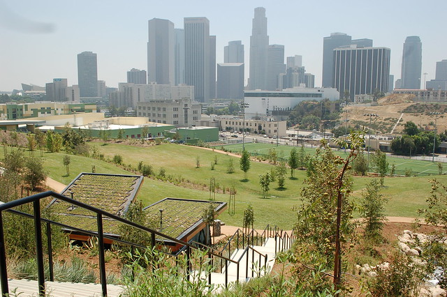
Other entries on parks in Los Angeles on this site have already established that the city suffers from a lack of adequate park space in relation to it's massive size. This fact belies the stereotype that Los Angeles is an open space and outdoor enthusiast's paradise, with great weather to enjoy it year-round. The reality is that the inner-city of Los Angeles is a densely-populated metropolis with little in the way of preserved parks or open space, and much of the city's population does not have access to the massive amount of open space on the coastline or the outer edges of the city. This is the main reason why Vista Hermosa Natural Park is an incredibly important new resource in the city. It provides a valuable open space outlet on the western gateway to downtown to a larger community that desperately was in need of one.
Vista Hermosa holds the distinction of being the first public park built in the core of Los Angeles in over one hundred years. Opening in the summer of 2008, the park is a welcome new addition to the city, and has been well-received since its inception. The park is now a favored green space in the city, and features stunning views of the city's famous skyline. It is relatively small in size at 10.5 acres, but it fills an incredibly needed niche. The park provides a slice of Southern California natural beauty in the heart of an area dominated by lack of open space and a heavily minority working-class population. It helps to fulfill the park void in a city where only a third of its residents live within a quarter-mile of a park, according to a 2004 Trust for Public Land study. It is facts like that that make the city one of the most park-deprived urban centers in America, which is unfortunate due to the incredible potential, geography, and climate of the area.
The park sits on a plot of land that had been the subject of land use and political battles for over a decade before development of the park. When it was finally decided to be used as parkland, the park was designed as a model for urban sustainability and revitalization within the city. It was also the result, as parks like these so often are, of a public-private partnership between the Santa Monica Mountains Conservancy and The City of Los Angeles, as well as various private funding sources and a grant from United States Department of Housing and Urban Development (HUD). The park combines a modern design with preserving historic natural qualities of the region. The park successfully restored much of the natural topography and vegetation of the area, as it features, trails, streams, meadows, oak savannahs, all interspersed with native Mediterranean vegetation. The park also provides an environmental education center which promotes the native life of the park as well as the green technology. The design process sought to maximize energy efficiency while minimizing environmental impact. The result is that the park is a self-contained watershed filled with permeable surfaces and green roofs on all structures. All of the water in the park is captured and re-used to water the park during prolonged droughts, which are regular occurrences in Los Angeles.
In the end, Vista Hermosa Park is a valuable asset for the city. It combines creation and preservation of open space with forward-thinking green technology that will help in sustaining the park's presence. Moreover, it allows urban-dwelling Los Angeles residents with little mobility access to attractive public park space. The city finally seems to be getting the right idea in regards to parkland, and Vista Hermosa is a great step forward.
Monday, April 8, 2013
Bryant Park

Bryant Park is an example of a park that, despite it's small size, plays an incredibly key role in the area in which it is located. It happens to be located in perhaps the busiest neighborhood in America, and therefore is a very natural attraction within it. Bryant Park is located just to the east of Times Square, the tourist epicenter of Midtown Manhattan in New York. Although it is only 9.6 acres in size, it provides an essential component of life in one of the most densely developed areas in the world. However, it's pristine present-day condition is not coincidental, and has taken plenty of effort.
The fortunes of Bryant Park have coincided with the trajectory of not only the Times Square area but also New York City as a whole. Although the park site has been designated as public land since 1686, it was not until 1847 that the first official park opened, then known as Reservoir Square. It was used for military drills during the Civil War, and it was finally named Bryant Park in 1884 after William Cullen Bryant, a notable New York Evening Post editor and abolitionist. By 1899, the reservoir on the site had been removed and construction began on the famous New York Public Library, which overlooks the park to this day. It was in this era of development at the turn of the century that much was invested in the park, including landscaping, terraces, and public facilities. However, the park quickly fell into neglect during much of the twentieth century.
The park, which featured all the potential of being a grand public centerpiece in the neighborhood, deteriorated during the city's economic and social struggles that reached a boiling point in the 1970s. The neglect really began in the 1920s, when the northern half of the park was closed due to the construction of Interborough Rapid Transit (IRT) subway tunnel that was being constructed along 42nd Street, as the city used the valuable space to store equipment. Over time, the park lost favor with much of the community, and a seedy element began to move in, much like nearby Times Square. In the 1970s, the park became a notorious spot for all sorts of unsavory activity. Drug dealers, prostitutes, and homeless people dominated the park, and it was considered by the larger public to be unsafe and even dangerous. By the turn of the 1980s, several concerned citizens teamed up to address the future of the park.
It was in this spirit that the Bryant Park Corporation was born. A group of prominent citizens and nearby property owners had a vested interest in restoring the park to its original intended glory, while also revitalizing the surrounding neighborhood. It was initially supported by the Rockefeller Brothers Fund, but has since transitioned to a funding based on assessment from nearby businesses and property owners, who all enjoy the benefit of close access to the revitalized park. Between the 1980s and the 2000s, the park underwent a radical transformation as a result of this effort. Due to the Corporation's effort's, which controls the park's operations, the park has a dedicated maintenance staff, has improved street entrances, outstanding public facilities, and an extensive collection of public seating, which is a main attraction to the park in it's dense surroundings.
Currently, Bryant Park is one of the key examples of the revival of New York City at the turn of the twenty-first century. The park is an important functioning element of life in busy Midtown Manhattan. It is a place to gather and relax, rather than to avoid. Real estate values in the surrounding area have skyrocketed, and Bryant Park has definitely contributed to it. It is a prime example of a group of concerned citizens taking charge and redirecting a valuable public land for the beneficial use of the public. The result is one of the most popular public spaces in New York City.
Sunday, April 7, 2013
Central Park - New York, NY
Central Park is the most celebrated urban parks in not only America, but possibly the world. It is the public centerpiece of the largest city in America, and is the most heavily used park in the country as well. It is a top attraction for tourists and residents alike, as they are both drawn to the undeniable qualities the park offers. Over 35 million annual visitors can attest to the park's charms as well as the important role it plays. Central Park is the classic definition of an urban park and the prototype on which countless other parks around the world have tried to emulate. It provides a free sanctuary from the chaotic and dense urban environment of New York City. It also acts as one of the most vital and effective economic development catalysts in not only the city, but perhaps the entire country.
The park began to be developed at a time of incredible growth in New York City's population. It also coincided with the rising belief in the positive benefits of adequate public space in crowded urban areas. The park began to be created in 1857 in an area of Manhattan that was largely different from its present-day development character. The northern part of the island had yet to be densely developed, but it was being rapidly encroached upon. The city decided it would be in the best interest of everyone to preserve a large tract of land for public space, which was a revolutionary tactic in a time where open space was often an afterthought. This was especially true in New York, where dense development dominated with little regard given to park or public space. Frederick Law Olmsted and Calvert Vaux won a design competition that was put forth by the city, and their job was to create large public centerpiece in the city. They accomplished that feat and so much more.
Olmsted desired to bring the grand public parks in various cities across Europe, which he personally experienced, to America. The design and construction process was very comprehensive, as the park today is not a representation of the natural landscape. The terrain was altered throughout the park's territory and soil was transported from areas such as New Jersey because the original soil was not thought to be strong enough to support the amount of trees and other landscaping throughout the park. Numerous ponds and lakes were implemented as well ,and they quickly became favored spots in the park. Over time, the park became home to an impressive amount of sculptures, monuments, and other public art.
Not much else really needs to be stated about the park, as it has been re-hashed over and over again since its inception. However, the park has not been without its challenges, and its fortunes and history has largely coincided directly with New York City as a whole. The park was a grand success when it first opened as the city was growing and establishing itself as the economic and cultural capital of America. However, for much of the 20th century, the park fell into neglect and disrepair. Maintenance was often overlooked and the architecture of the park suffered. There was little effort to remove things such as dead trees and vandalism became prevalent throughout many areas. By the 1960s and 70s, the park became an area almost to avoid by average New Yorkers and tourists, especially at night. It was considered unsafe and became a haven for crime and antisocial behavior. The park's story was consistent with New York City as a whole, as the 1970s brought turmoil and population decline to the city. However, renewed investment in the park, under the operation of the Central Park Conservancy, has revitalized it and made it perhaps more impressive and welcoming than ever.
In the end, Central Park is the ultimate example of the positive effect a well-designed public space or park can have on its surrounding area. It is not a coincidence that Central Park borders perhaps the priciest and most desirable real estate in not only America, but the world. In New York City, having an address close to the park or even across from it is a highly sought-after status symbol. The park also contributes heavily to the quality of life for New Yorkers of all kinds. True to its name, it is centrally located in the city, allowing easy access for people from differing areas of the massive city. In a city largely without private green space or yards, especially in Manhattan, Central Park functions as a communal yard in which everyone takes pride. It is a valuable spot for events, gatherings, relaxation, and exercise. It is also one of the key components for positive economic development in its area. One cannot ask for much more from a park.
The park began to be developed at a time of incredible growth in New York City's population. It also coincided with the rising belief in the positive benefits of adequate public space in crowded urban areas. The park began to be created in 1857 in an area of Manhattan that was largely different from its present-day development character. The northern part of the island had yet to be densely developed, but it was being rapidly encroached upon. The city decided it would be in the best interest of everyone to preserve a large tract of land for public space, which was a revolutionary tactic in a time where open space was often an afterthought. This was especially true in New York, where dense development dominated with little regard given to park or public space. Frederick Law Olmsted and Calvert Vaux won a design competition that was put forth by the city, and their job was to create large public centerpiece in the city. They accomplished that feat and so much more.
Olmsted desired to bring the grand public parks in various cities across Europe, which he personally experienced, to America. The design and construction process was very comprehensive, as the park today is not a representation of the natural landscape. The terrain was altered throughout the park's territory and soil was transported from areas such as New Jersey because the original soil was not thought to be strong enough to support the amount of trees and other landscaping throughout the park. Numerous ponds and lakes were implemented as well ,and they quickly became favored spots in the park. Over time, the park became home to an impressive amount of sculptures, monuments, and other public art.
Not much else really needs to be stated about the park, as it has been re-hashed over and over again since its inception. However, the park has not been without its challenges, and its fortunes and history has largely coincided directly with New York City as a whole. The park was a grand success when it first opened as the city was growing and establishing itself as the economic and cultural capital of America. However, for much of the 20th century, the park fell into neglect and disrepair. Maintenance was often overlooked and the architecture of the park suffered. There was little effort to remove things such as dead trees and vandalism became prevalent throughout many areas. By the 1960s and 70s, the park became an area almost to avoid by average New Yorkers and tourists, especially at night. It was considered unsafe and became a haven for crime and antisocial behavior. The park's story was consistent with New York City as a whole, as the 1970s brought turmoil and population decline to the city. However, renewed investment in the park, under the operation of the Central Park Conservancy, has revitalized it and made it perhaps more impressive and welcoming than ever.
In the end, Central Park is the ultimate example of the positive effect a well-designed public space or park can have on its surrounding area. It is not a coincidence that Central Park borders perhaps the priciest and most desirable real estate in not only America, but the world. In New York City, having an address close to the park or even across from it is a highly sought-after status symbol. The park also contributes heavily to the quality of life for New Yorkers of all kinds. True to its name, it is centrally located in the city, allowing easy access for people from differing areas of the massive city. In a city largely without private green space or yards, especially in Manhattan, Central Park functions as a communal yard in which everyone takes pride. It is a valuable spot for events, gatherings, relaxation, and exercise. It is also one of the key components for positive economic development in its area. One cannot ask for much more from a park.
Thursday, April 4, 2013
Discovery Green - Houston, TX

Discovery Green is a 12-acre park located in the heart of downtown Houston. It lies in the shadow of the city's skyline and is one of the few public green spaces within the densely developed area. It is a positive example to follow on numerous fronts. First, the park was the result of a public-private partnership that is often so essential in the creation of such a project. The park was also just recently created in 2008, which is symbolic of the growing favorable attitude towards the importance of providing adequate green space within urban areas. Finally, the park reclaimed under-used and unattractive land, as it was built on the site of two large surface parking lots. Now, downtown Houston has a tranquil and large park within the business heart of the city.
The park is the result of a vision that was put into action by several well-connected Houston philanthropists. Their wish was to transform the landscape of downtown into something more livable and vibrant. They seized the opportunity of developing an undeveloped site used for parking into a valuable park space that would promote the quality of life and business opportunities within the neighborhood. On all sides, the park is surrounded by dense development, including the George R. Brown Convention Center, which holds a large concentration of out-of-town visitors on any given day. Therefore, the park is a destination for residents, tourists, and business travelers alike. It has become nearly exactly what the minds behind the park had envisioned when they began their development efforts. They realized the potential of the land as it had not always been in such an under-used condition. In fact, it was originally the site of a high-end residential neighborhood in the early 20th century that grew. As the residential area deteriorated and dense downtown development dominated, the area was cleared and parking lots were put in place to accommodate automobile culture.
In 2002, the city of Houston purchased a portion of the land. Shortly thereafter, the rest of the site's property went up for sale, and a the group of philanthropists approached the city with the idea of turning the site into a park. The city agreed and, in 2004, purchased the remained of the site while advocating the merits of a public-private partnership. The city agreed to provide funding and support for the park, while handing over operational controls to Discovery Green Conservancy, a nonprofit organization. In the design process for the park, the public played a pivotal role. The current state and design of the park is largely a result of this public process. As a result, the park is has been showered with rave from the general public.
In the end, the park, while new, has been an enormous success. It is a catalyst for changing the perception of downtown Houston. It is now a place to enjoy and play, besides being a neighborhood strictly for business. It has increased civic pride in the area and people have less of an incentive to jet away from downtown at the end of the work day. It is also the result great cooperation and follow-through among the public and partnering entities. It shows what can be accomplished if several strands of a community share a vision and have the initiative to implement it.

Subscribe to:
Posts (Atom)