Wednesday, January 30, 2013

Lakeside Park - Oakland, CA


Oakland is routinely overlooked by San Francisco, its larger sibling located directly across the San Francisco Bay. Therefore, Oakland always seems to be in the shadow of the world famous city that lies only 8 miles away. Some of this is deserved, as San Francisco has long been established as a favored vacation destination as well as one of the most desirable places to live in the United States. The density of the city as well as its real estate prices can attest to that notion. While San Francisco seems to routinely receive all of the adulation and attention associated with such a distinction, Oakland for a similarly long time has been popularly viewed as a working class or even dangerous town, with perhaps even worse claims at times. However, Oakland is still a large city with many amenities and several desirable areas, although presented in a quieter and less grandiose fashion than its sibling across the bay for which it is forever linked.

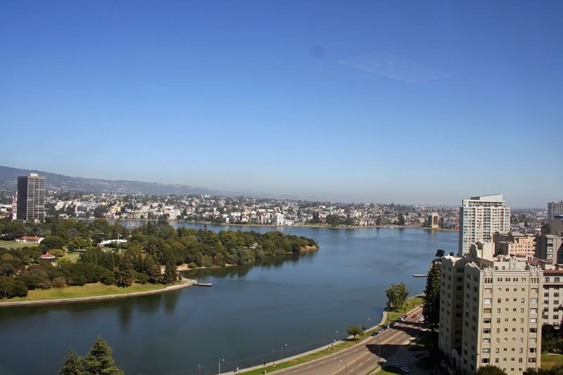
One thing Oakland can claim as being a tad better than San Francisco in is its climate. Located on the east side of the bay, Oakland is often sunnier and a bit warmer on days when San Francisco is socked in by fog from the Pacific Ocean and Golden Gate all day. Therefore, Oakland residents have ample opportunity to use their public parks and recreation areas in relative comfort. The favored destination for outdoor activity within the city is Lake Merritt and Lakeside Park, which spans its perimeter. The lake is located directly in the heart of downtown Oakland which adds to its scenic nature. As shown in the picture at the top, high-rise buildings march right up to the lake, giving the park a sense of space and grandeur. Therefore, it is also a favored lunchtime destination for the people that work in the buildings within close proximity to the park. Therefore, the park doubles as the favored recreation and exercise location in the area as well as acting as an escape from the urban jungle. The park is also a key asset in promoting the real estate value of its surrounding area. Private residences that are within close proximity to the lake or command views of it are among the most desirable in the city. The park is always at the top of advertised amenities for real estate in the area.


Lake Merritt was originally a tidal lagoon that was directly connected to a part of San Francisco Bay. As such the area often acted as a gathering point of sludge and contaminated water from the heavily used Bay and the nearby ports. In 1867, Dr. Samuel Merritt, the mayor of the city and property owner on the shore, became determined to clean up the body of water in order to turn it into a civic centerpiece. He funded a dam between the estuary and the bay in order to control the flow of water and turn the lagoon into a lake. The resulting lake, as one could possibly infer, is named for him. The lake had also long been a destination for migratory birds due to the wetland qualities that the lagoon possessed. Once the lake was created, the birds continued to favor it, and as a result it was established as a National Wildlife Refuge in 1870, the first ever in the United States. Once the lake was established, concerted efforts were made to landscape and maintain the perimeter. The northern edge of the lake in particular, which forms the majority of Lakeside Park, is home to a large tract of preserved land set aside for public use and enjoyment of the lake. Overall, there are over three miles of paths that circle the complete perimeter of the lake. Cyclists, joggers, and walkers all take full advantage of it on a daily basis.

Lakeside Park and Lake Merritt are outstanding examples of a city artificially creating a prime public land destination. Oakland transformed a polluted, unattractive, and untamed waterway into perhaps the crown jewel of not only of its park system, but the entire city. The creation and maintenance of public parkland has turned the surrounding area into a destination and one of the most prized and economically viable areas in not only the city but the entire East Bay region. Lakeside Park is the result of many years of proper foresight and planning and the city has seen its investment in it more than pay itself back.

Oakland has had a turbulent history and has had more than its share of socioeconomic problems. The city still suffers from a troubled economy and a relatively poor population. It also will never be on the same pedestal as San Francisco, and will always be mentioned with it due to the geographic area in which they share. However, Lakeside Park stands tall as a source of civic pride. Few other places as urban as Oakland can claim to have such a large well-maintained lake for public use right in the heart of its urban core. Perhaps, that will drive all the tourists and other residents of the Bay Area who never set foot in Oakland to visit. After all, it is only a short, if traffic-clogged, car ride on the Bay Bridge or a few stops on the BART train away from the city across the bay.


Tuesday, January 29, 2013

Patterson Park - Baltimore, MD


The City of Baltimore is often synonymous with urban decay. Therefore, outsiders who have no other knowledge of the city often have extremely negative preconceived notions of it. It is a reality that the city is marked by high rates of crime and poverty and has experienced a sharp decline in population since the mid-twentieth century. Media depictions, such as HBO's epic series "The Wire", have helped fuel the feeling by many that the city is a dangerous area far beyond repair. However, there are some parts of the city headed in a positive direction. These relative success of these areas is almost directly related to the waterfront or public park space within close proximity to the neighborhoods. Baltimore is not a lost cause, partly due to its strategic location within the urban Northeast Corridor, just north of Washington D.C. on I-95 as it heads towards Philadlephia and points north and to the east. The waterfront, along the shore of expansive and famous Chesapeake Bay, is also an enormous advantage for the city.

Public space and parkland play a key role in the health of Baltimore's most vital neighborhoods. Patterson Park is an example of a large urban park that plays a key role within the city. One of the fastest growing areas of the city is the neighborhood right next to the park, not coincidentally also Patterson Park. The positive aspects of living in such close proximity to the a large park is a key selling point in the revitalization of the area. The park itself is situated in the eastern part of the city within close proximity to the waterfront of the Baltimore Harbor. The land lies on a pivotal area in the city's history. As a result, the city has taken a proactive approach in preserving it for the public since the early 1800s. It all began when William Patterson, for whom the park is named, offered the city six acres of his property that overlooked the harbor from a small hill. He was inspired by the public walks he had experienced in Europe and wanted to create something similar in Baltimore. By the 1850s, the city had purchased another 29 acres from the heirs of Patterson and the park was on its way to success. By 1860,  the city acquired an additional 30 acres and began to model it after Central Park in New York. However, once the Civil War began, it became a key encampment for troops and a hospital was put on its grounds. Hempstead Hill, the high point of the park, was a strategic outpost and fortification for the troops. Once the war ended, the park was in a state of disrepair.

It was at this time that the park adapted the character for which it is known today. The Victorian landscaping that remains today is a result of this process The famous Pagoda, designed in 1890 by Charles Latrobe and pictured at the top of this entry, is a remnant of this era. The well-known marble fountain,pictured below, also dates to this era and was one of the first restoration efforts after the war. The park was then also designed to be a recreation destination. There are public fields and courts as well as miles of relatively flat and gentle walking and jogging paths. This is a crucial element of the park as the surrounding neighborhoods of Baltimore are extremely dense and offer little in the way of safe and adequate areas for recreation or exercise.


As already mentioned, the neighborhood of Patterson Park has been on an upswing in recent years. As urban living among young people becomes increasingly desirable, neighborhoods such as Patterson Park will experience an increase in vitality. The neighborhood offers urban living, older, affordable homes ripe with character and charm, and access to large tract of classic open space. Many townhouses that were once abandoned have now been restored and thoroughly modernized. Now, the neighborhood is safer than most in the city, has less vacancy, and property values have gone up sharply since the 1980s. The location of the neighborhood, next to a large public park and close to the waterfront, has helped immensely in this reversal of fortune. Location is a key aspect in urban revitalization. It is especially crucial if a large public lands are within close proximity as well as other nearby economic growth, either locally or regionally. Baltimore and Patterson Park have both of these aspects in their pocket. Now hopefully the rest of Baltimore can make some progress as well.


Saturday, January 26, 2013

Fairmount Park - Philadelphia, PA


Fairmount Park is one of the largest city parks in the United States. With a size of 4,167 acres, the park commands an overwhelming presence in the northern part of Philadelphia. The natural land the park protects and preserves stands in stark contrast to one of the most heavily developed and densely populated cities in America that surrounds it. As the park offers almost limitless recreation opportunities and access to nature within city limits, it plays an extremely valuable role in the fabric of Philadelphia life. It is the centerpiece of the Philadelphia park system and allows residents an escape from hectic city life as they completely immerse themselves in the atmosphere of the park. When the canopy of the trees and vegetation are fully in bloom, it is possible from many points in the park to completely disassociate from the city as the tall buildings and other infrastructure become fully obscured and distant.

The park spans both sides of the Schuylkill River in the northern section of Philadelphia. It is yet another example of an urban area taking an early proactive approach in land preservation to promote the welfare and quality of life of the general public. If the park did not exist, it is completely conceivable that many of the areas within the park would be extremely valuable parcels of real estate. As the park is along the river and varies in elevation, several prized neighborhoods would probably exist full of nice homes. However, the land was made public by the city and it is now one of the top destinations in the region for all kinds of people. Besides its land preservation importance, the park also doubles as a grand urban nature preserve as well as an one of the most immaculately landscaped and designed parks in the country. At first, the park was preserved purely along the river as an effort to preserve the water supply for the substantially growing city in the 1800s. By 1865, the city acquired a significant portion of the present-day park that had yet been developed. These areas of the park along the water in the northern and western sections of it, are largely untouched besides the development of trails. It gives into the Pennsylvania countryside that largely existed throughout the entire urban sprawl of the Philadelphia metropolitan region before it became one of the important centers of American life.


The park is also home to beautiful landscaping and architecture, as well as many of the most recognized landmarks in all of Philadelphia. The oldest section of the park is nearest to Center City Philadelphia and the majority of the city's tourist attractions. Therefore, it is also one of the most visited and heavily photographed areas of the park. In this area of the park lies the famous Art Museum. Directly behind and to the north of the museum along the Schuylkill lies the beautifully maintained and historic walkways of the Philadelphia Water Works, which have been in place as urban public land since the 1830s. This area was once the heart of the city's water supply activity from the river. Therefore, it doubled as an important civic infrastructure source as well as a valuable open space outlet for the growing city's residents.


While Fairmount Park is certainly an incredible civic asset and a model to follow for urban parks and land preservation, it has the potential to be so much more. Located directly to the east of the park lies the vast neighborhoods of North Philadelphia. Despite having such close access to a treasure such as Fairmount Park, North Philadelphia is one of the most struggling and disinvested areas of the entire city. North Philadelphia has long been synonymous with urban decay and has some of the highest rates of poverty and crime of any area of any major city in America. This is an unfortunate reality, as the park has the incredible potential to be an effective community development tool, especially for youth in the area. So much more could be done in the park to provide an outlet for structured activities for those in the surrounding neighborhoods. There are efforts, but more could be achieved due to the incredible size of the park and the large, dense population of North Philadelphia. It is a conundrum that one of the most dangerous and dense urban areas of America lies within such close proximity to one of the largest urban natural preserves in the country. The physical infrastructure is already there. Some have already realized this incredible potential and have utilized the land for such purposes. Here is an example of an innovative idea in action:


Access to open space has an incredible positive effect on quality of life. This is especially true in dense areas such as Philadelphia. Hopefully, more will begin to realize the potential it can have alleviating many problems associated with such areas.

Tuesday, January 22, 2013

Grant Park - Chicago, Il


Grant Park is a classic centerpiece of one of America's grandest cities. Chicago is characterized by its architectural beauty as well as its forward thinking in urban planning practices and preservation of key open space. One of the main attractions in the city is the uninterrupted greenway that spans the significant length of the shore of Lake Michigan. Due to the size of the lake, it is almost as if one were on the edge of a vast sea or even ocean, as you can not see the other side of the lake from Chicago. Confronting the lake from the heart of downtown is Grant Park, which serves as an invaluable civic treasure to the city as well as one of the nation's finest waterfront parks.

With a size of 319 acres, Grant Park commands an incredibly large amount of real estate in the heart or the urban bustle of the city. It is surrounded on three sides by skyscrapers and a heavily dense urban environment. On the fourth side is the tranquility offered by Lake Michigan, which serves a very valuable purpose for the quality of life in the city. The park allows urban dwellers and workers alike public access to this desirable area and presents an area for relaxation, recreation, or various other opportunities that are otherwise limited in the heart of the nation's third largest city. Due to its location and amenities, the park is often referred to as "Chicago's Front Yard". This term is attributable to the fact that locals treat the park as a daily fabric of their lives and use for various purposes as if it were their own. In that aspect, Grant Park is truly a public space that has been properly preserved.

The land was officially designated by the city as a park in 1844, with the name of Lake Park. By 1852, the Illinois Central Railroad was allowed lay its tracks along the lakefront, which, in turn, resulted in a stagnant lagoon just to to the east of the tracks along the water. By 1896, the city began extending the park into the lake with landfill to the east of the rail lines in an effort to take advantage of the incredible potential of the site. The city realized the importance of public land and took a proactive effort to artificially create it for civic, public health, and economic development purposes. By 1901, Lake Park was renamed Grant Park in honor of Ulysses S. Grant, the former United States President and Civil War General. Throughout the early 20th century, the park was expanded with even more landfill and was formally landscaped in a grand fashion that was in tune with the architectural grandeur of the surrounding city.

Throughout the park are numerous paths, gardens, and monuments that wind through its boundaries. It also serves as one the largest spaces for public gatherings and festivals in the entire region. Much has been written about this before and an exhaustive list of these qualities could continue indefinitely. Instead, a quick number of select pictures will suffice as a monument to perhaps the greatest public space in of America's largest and most important cities.


Finally, Grant Park was the setting for one of the most important moments in American history. It was where Chicago resident Barack Obama gave his famous victory speech on the night of November 4, 2008 when he defeated John McCain to become president of the United States. The grand amount of public space was definitely fully utilized on that night:


Saturday, January 19, 2013

Griffith Park - Los Angeles, CA


Griffith Park is the largest municipal park in the city with the second largest population in the United States. Located on the northern stretches of the city overlooking the vast basin of downtown Los Angeles and its miles of surrounding and outlying development, the park commands an extremely valuable tract of real estate within Southern California that the entire public can enjoy for its numerous advantages. The park is over 4,310 acres, which establishes itself as one of the largest urban parks in the country. It lies on hilly and rugged terrain, which not only adds to its wild and unkempt character, but also its famous views of downtown Los Angeles and the massive overwhelmingly flat areas that surround it in every direction.

Located at the eastern end of the scenic Santa Monica Mountains, the park was officially created in 1896, and his since morphed into one of the most visited parks in the United States. It is one of the main tourist attractions in one of the most heavily visited cities in America. Furthermore, the park is heavily used by residents as valuable hiking and recreation destination as they take advantage of the rugged terrain and the numerous trails, paths, attractions, and amenities that are present throughout the park. It is also one of the most recognizable parks to the general American public whether they have been there or not due to it incredible proximity to Hollywood, of which it is just uphill and to the east. The park is a one of the most common filming locations for films and television shows in a city and region in which the film and entertainment industries dominate. Due to its close proximity to the capital of production studios, and the varied terrain that is present throughout its boundaries, Griffith Park is naturally a favored filming and production location. It represents areas throughout the world that are not supposed to be in Los Angeles. It is a testament to the varied terrain and topography within the park. The preservation of this land as open space is also a key positive economic development indicator for the city of Los Angeles and its surrounding region. The open space that it affords allows the city to continue to dominate its claim as the film and television capital of the world.

The park itself also plays an important role in the quality of life for residents of Los Angeles. It allows for an oasis of natural beauty within the crowded metropolis of urban Los Angeles. The park is located well inland from the coastal open space of which the city is often equated. Therefore, the park allows easy access to natural open space for residents who do not live within a just a few miles of the Pacific Ocean. In the nightmare that is the Los Angeles traffic and freeway system, this is a huge advantage. As Los Angeles is a heavily paved metropolis, the park allows residents and visitors to experience a natural Southern California ecosystem without leaving city limits. Typical of the region, the park ranges in altitude from 384 to 1,625 feet above sea level, which make it a premier urban hiking destination. Due to the arid climate, many native plant species such as coastal sage scrub and oak woodlands thrive in the numerous deep canyons and steep hillsides that wind throughout the park. This landscaping patten allows the city to reduce its cost in regards to maintenance to this civic treasure.

Besides its many natural treasures, Griffith Park is also a cultural destination for the city. The Los Angeles Zoo, the premier areas for viewing wildlife in the metropolitan area, is locate within its boundaries. Also, the famous Greek Theatre is located within the park. The 5,700 seat theater is an extremely popular destination for concerts and related performances for acts from around the world. Finally, the park is home to the Griffith Observatory, perhaps its most famous landmark. Sitting on the southern slope of Mount Hollywood, the observatory commands an impressive views of the Los Angeles metropolitan region, everywhere from the Pacific Ocean to downtown, and to both the south and east of the downtown skyline. Opened to the public in 1935, the Observatory has since been a top attraction for both residents and visitors alike.

Despite its reputation as a recreation lover's paradise, the city of Los Angeles actually suffers from a dearth of public parkland. There are huge swaths of urban development throughout much of the city without much in the way of land set aside for public recreation. Griffith Park helps to make up for this shortfall by providing a giant open space. However, Los Angeles could do much more for its citizenry in regards to open space. But the city must be applauded for setting aside an area that would be one of the most highly desired real estate in the region for public use. Where else can you experience a hiking path such as this within one of the largest cities in the country:


Thursday, January 17, 2013

Forsyth Park - Savannah, GA


Savannah is a city that owes much of its unique character to ongoing efforts to preserve and promote open and public space. It is a dense urban oasis full of architectural and historic grandeur located in Southeastern Georgia. The city is home to one of the largest National Landmark Historic Districts in the Unites States. This historic district also coincides with the area of the city from which the majority of its economic engine originates. The downtown area, the riverfront, and surrounding areas are all encompassed within this district. A remarkable and unique characteristic of this area of the city are the the high number of public squares that abound with greenery that are scattered throughout its roadways. As a result, Savannah has a surplus of public space and walking instead of driving is an extremely attractive option. Besides the the squares that characterize the unique flavor of the city, Savannah does have a large park located within the district as well. Forsyth Park is a favored destination for locals and tourists alike, and it serves as the flagship park of the city's open space system.

The park, which was established in the 1840s and expanded in the 1850s, is rectangular in shape and occupies 30 acres in total. It is bounded on all four sides by dense city development, and is therefore a very popular destination for residents. An abundance trees are scattered throughout sections of the park and its paths, which allow for a pivotal shade area, which is extremely valuable during the hot and humid days that are characteristic of Savannah and it southern climate throughout the late spring and summer. The park is also immaculately landscaped, with many native trees and plants littered among the architectural and monumental gems. In 1858, a popular fountain was added at the northern end of the park and is modeled after the fountains in the Place de la Concorde in Paris. This was consistent with the overwhelming inspiration the nineteenth century urban renewal of Paris had on the creation and design of the park and its surrounding area. Around St. Patrick's Day, it is a tradition for the fountain's water to be dyed green, which is an homage to the historic Irish influence and presence in Savannah.

The park also acts as a recreational focal point for the local community. There are numerous paved walking and running paths as well as a large children's play area. There are also tennis courts, basketball courts, and large areas available for soccer and Frisbee activities. There is also large expanse of open grass space that is smaller version of the Great Lawn in Central Park, if a comparison was needed.

As is a running theme in highly successful urban parks, some of the most highly desirable real estate in Savannah lies within close proximity to the park's boundaries. A main selling point to living in this prized area of town is the access to the park and the high quality of life that it guarantees. In a city that helps to perfect the idea of an urban forest, Forsyth Park is an essential component to the life of the city. While the various small plazas and squares serve their purpose, a large outlet of open space for relaxation and recreation is needed. Forsyth Park serves that role, and is an example of a wonderfully maintained public park, even with the giant, and exquisitely beautiful, monument to the struggle for the Confederacy in the heart of the park. After all, Savannah is in the heart of the south...

Thursday, January 10, 2013

Rittenhouse Square - Philadelphia, PA


Rittenhouse Square in Philadelphia is a prime example of the benefits properly maintained public space can have on the neighborhood in which it is located. The park, which is essentially a public plaza and square, is more suited for relaxation than full-fledged recreation. However it is classified, Rittenhouse Square plays an invaluable role in its neighborhood and is an incredible asset in Center City Philadelphia, which has experience a renaissance in the past twenty or so years. One of the most desirable areas within Center City is the neighborhood surrounding Rittenhouse Square, which itself is named after the square.

The fact that the area in close proximity to the square is so desirable is not a coincidence. It is directly related to the presence of the square, which is a beautifully manicured and maintained public green space in the middle of a densely settled area with a lack a distinct lack of open space and greenery. Even in the most dense of environments, people tend to be attracted to a bit of open space. Although quite small in size, Rittenhouse Square accomplishes the feat of providing a sense of openness in tranquility to Philadelphians in the midst of their very urban setting. The park is bordered on its sides by high-rises full of luxury apartments and condos, which serve as a testament to the viability of the square. A main selling point to these high-priced living quarters is either its view of or proximity to the square, or perhaps even a combination of both. Restaurants, retail, and offices also are located within proximity, which all attest to its desirability. When everything is taken into account, the neighborhood is a highly vibrant, mixed-use destination, and the centerpiece of it is public park.

Rittenhouse Square is one of the oldest continuously-used public spaces in America. It was one of the five original open space parks planned by William Penn in his original design of Philadelphia in the late 17th century. It has not gained size since, and as such, is only two blocks in size on all four sides. However, its small stature belies its importance and beauty. It is immaculately maintained and features various sculptures that add to its character.The lion statues are a particular delight to the large cast of daily workers and nearby residents who gather during the day to relax or eat lunch on the benches scattered throughout its walkways.


Rittenhouse Square proves that a park can be small in size and forgo traditional recreational facilities and still be an incredible success. Rittenhouse is a Philadelphia institution simply by providing a manicured green space in the heart of the city. Instead of exercise, the park is mainly used as a place of respite and relaxation from the hustle and bustle of urban Philadelphia life. Philadelphia is a huge, diverse city with its share of nice and not-so-nice areas. Rittenhouse Square has long been one of the most desirable and high-priced areas in the city, and it is directly related to the establishment and maintenance of a relatively small parcel of open space. It is a prime example of the economic and quality of life benefits that arise from the creation of attractive public spaces.


Tuesday, January 8, 2013

Forest Park - Portland, OR


Portland, Oregon has long been a city that has done things its own way. It is a city that is isolated both geographically and culturally from the majority of the United States. Therefore, Portland has been able to establish itself as a true visionary and an original thinker in regards to many aspects of its city. The city has long been admired as forward thinking and progressive in its urban planning policies and practices. Among the most famous of these practices is its urban growth boundary. Although it has it share of detractors and critics, the urban growth boundary clearly delineates the extent of where Portland can develop. This creates a relatively dense and compact city that abruptly transforms on its edges into an area of abundant open space and farmland. This is opposed to monotonous sprawl that unfortunately characterizes the edges of almost every other major urban metropolitan region throughout the country. Along with its efficient transit system, Portland has been very proactive in preserving open space and parkland within its city limits.

The crown jewel of the city's municipal park system is Forest Park, which is located northwest of downtown Portland. It is a massive park, one that stretches over 8 miles in length in a northwest to southeast direction. It is located in the Tualatin Mountains on a series of bluffs that overlook the Willamette River, which flows through the heart of Portland. It affords residents of the city a taste of Pacific Northwest forest wilderness within minutes of the urban character of downtown Portland. The majority of the park is an example of land preservation that has been untouched and allowed to remain in its original form. In the Pacific Northwest, this equates to a dense forest environment, where wildlife and a diversity of plant species are abundant. The terrain is also very hilly, allowing for challenging hiking and biking trails within a highly developed city. It is a critical component of a highly maintained regional system of parks and trails, and it covers more than 5,100 acres in all. It is almost as if one has entered an entirely different world, even though the city is only a few miles away, as is illustrated in this aerial photo of the park looking in an eastern direction:


The park is an incredible asset in the role it plays in promoting healthy physical activity among city residents. Over 70 miles of recreational trails are present within the park, among the most of any city park in the country. As a result, the park is a very popular recreation destination in a city that is composed of a high number of outdoor activity enthusiasts. The expansive size of the park is a result of a long and exhaustive effort on the part of Portland residents and leaders to preserve natural woods within close proximity to the urban center that dates back as far as the 1860s. By the turn of the century, the Municipal Parks Commission of Portland was established and began to acquire the land slowly that now makes up the boundaries of the park. Over time, the park continuously connected a series of smaller parks to make up one uninterrupted greenway. Even today, the city and regional government agencies are acquiring more land to preserve in order to expand the park even further. There is no reason to not continue this effort as the northwestern boundary of the park lies along a vast stretch of relatively undeveloped forest.

The park truly serves a dual purpose. It is a large recreation area for the public as well as a relatively untouched reserve for wildlife. It is an important element of the park. By doubling as a reserve, where nature is allowed to let be, little is needed in economic cost besides maintaining trails and employing a staff to keep the park attractive. It also allows almost unfettered access to natural Northwest wildlife viewing within 5 to 10 miles of the biggest urban center in the entire state of Oregon. The natural beauty that the park promotes goes hand in hand with environmentally-friendly reputation of the state and most of the Pacific Northwest. Close access to such untouched and rugged landscapes promotes appreciation of these values among average citizens. It is another example of how Portland is thinking ahead and how the rest of the country and the world should perhaps follow suit in regards to open space.


Monday, January 7, 2013

City Park - Denver, CO


Denver is a city that is defined by its natural character and access to open space. It is what largely drives adventure-minded visitors to the city and its metropolitan area. This is owed to the fact that the city is situated precisely where the Great Plains meet the Rocky Mountains, making for a spectacular natural setting. Looking west, the Front Range of the Rocky Mountains stand tall and look over the city with a commanding presence. On the way up to the mountains, an abundance of recreation opportunities exist within the vast amounts of open space that unfold just outside the city limits. In fact, some of the most famous ski resorts in North America are located just two hours from downtown Denver. However, city residents and urban dwellers within Denver do not always have to travel outside the city to experience great outdoor and recreation opportunities.

City Park is exactly what its name suggests. It is an urban park situated squarely in one of the middle of Denver. It is a 330 acre preserve of parkland located just east of downtown Denver in the central part of the city. It is an old park when compared to the rest of the development of modern Denver. When it was first conceived and established in the 1880s, it was located outside of the settlement of the city at the time. therefore, Denver and its residents were forward thinking in its desire for establishing land for open space at an early time in its development. As the city developed eastward, all sides of the park began to be enveloped and surrounded by the built environment. By the early to mid 20th century, the park truly began to form its much needed role as a valuable open space preserve and respite from urban Denver life.

The park was partially modeled after the City Beautiful movement. As such, sculptures and architectural beauty and achievement play a prominent role in the landscape of the park. Despite the mountainous terrain that lies directly west of the city, Denver itself is located in the plains. Therefore, the park is located on overwhelmingly flat terrain, which increased the need for for man-made landscaping and structural imprints to create a lasting impression on park users. As a result, an abundance of sculptures are scattered throughout its boundaries. Here is a great example of this:


Besides acting purely as open space, the park also a acts as a cultural and tourist destination. Numerous festivals and gatherings take place in the park throughout the year as Denver residents take advantage of its wide space. The Denver Zoo and and The Denver Museum of Nature and Science are also located within the boundaries, which is not not an uncommon occurrence of a park of such magnitude in a highly populated urban center. Golf enthusiasts also take advantage of City Park Golf Course which lies along the northern edge of the park. The park also hosts one of the largest bodies of water within city limits in Ferril Lake. When taken all into account, with everything from trails, architectural beauty, water, and cultural attractions, the park is a prime destination for almost any resident of Denver and its surrounding area.

When people think of Denver, outdoor access and recreation naturally spring to mind, with the Rocky Mountains as a grand backdrop. However, not every resident of Denver has the mobility or adequate funds to leave the city limits and experience it for themselves. As a result, City Parks and parks similar to it fill an incredibly valuable niche for urban dwellers. It grants affordable and close access to open space and all the benefits that it offers. A large, centrally-located park such as City Park plays an essential role in promoting the quality of life for all Denver residents.