Sunday, March 31, 2013

Piedmont Park - Atlanta, GA


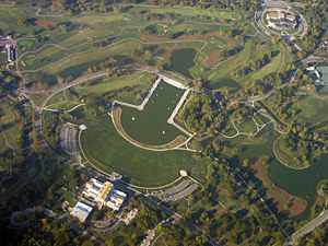
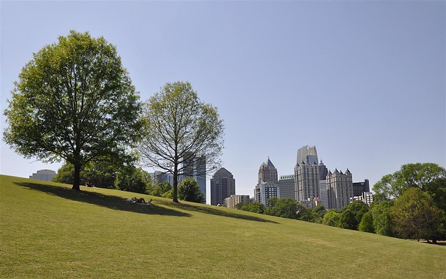
Piedmont Park in Atlanta, Georgia is a large public park located within a close distance to the heart of the downtown core of the city. It is located about a mile northeast of downtown and scenic views of the city skyline are available from many vantage points throughout the park. The park commands a 189-acre presence in the area and has long been established in the fabric of urban Atlanta. It is an historic open space that provides city residents with a valuable outlet for recreation, exercise, relaxation, and various other pursuits.

The park was completed by 1895, placing it among the top tier of urban parks that were implemented before 1900. The original purpose of the park was to provide a space for expositions to showcase the city and the surrounding region to outsiders and visitors. In the early 1900s, the park began a redesign effort led by the sons of Frederick Law Olmsted, the famous mind behind New York's Central Park and many other notable sites. The plan culminated int the addition of new landscaping and the addition of scenic paths and trails that wind throughout the park. As a result, the park became and continues to be a favored running and exercise outlet for residents of Atlanta. A large park had become a necessity in the rapidly growing city. Between 1860 and 1890, the population jumped from 9,000 to over 65,000 people. The city was rapidly becoming one of the most important cities in the South, and it desired to have grand public places to befit such an image. The preserved open space became the site for notable organized sporting events, such as the first baseball game between University of Georgia and Georgia Tech.


A significant highlight of the park is Lake Clara Meer, which is entirely within the park. It is very well-maintained and features an historic boathouse along its perimeter along with a pavilion, covered picnic areas, and a pedestrian bridge that crosses over it. The lake was originally a pond but was expanded t over 11 acres in preparation for the 1895 Cotton States and International Exposition. Park users are drawn to the lake area due to its boardwalk, a Visitors Center, and grand views of the downtown skyline. As Atlanta is not a waterfront city, the lake provides access to a waterway within city boundaries. This is valuable, as people are naturally drawn to waterfront areas.

The park has expanded since its creation and it continues to make efforts to expand currently, as the city realizes the jewel it is and the economic effect it has on the surrounding area. Atlanta is a city that has grown incredibly in size and importance since the late nineteenth century when the park opened. Now it can legitimately lay claim to being the cultural and economic capital of the south. The metropolitan area has transformed into a massive sprawl in each direction from the heart of downtown. As a result the region experiences some of the worst traffic in the country, as well as other negative qualities associated with massive growth in the age of the automobile. However, Piedmont Park is still intact from a time when Atlanta was a different place, and it's importance and role in the city's quality of life is just as pivotal as ever.


Friday, March 29, 2013

Louisville Waterfront Park


Louisville Waterfront Park lies on the banks of the Ohio River adjacent to downtown Louisville, the largest city in Kentucky. It provides valuable public access to the river as well as allowing for a substantial green space in the heart of the city. Created in 1999, it is a relatively new park that is the result of a redevelopment effort by the city in its urban core. The park is a successful re-creation of an area of the city that had fallen into under-use and was characterized by blight. It is one of the prime examples of a growing trend of turning abandoned or blighted areas in cities into public space or parkland.

Before the existence of the park, the site was home to various types of industrial use. It was home to the wharf area where Louisville first established its economy along the Ohio. Over time, various uses developed including scrap yards, rail lines, and sand pits. By the middle of the twentieth century, the wharf had been largely abandoned of productive economic use and was largely abandoned. This coincided with the rise of the age of the automobile and road and highway construction. Elevated highways, specifically Interstate 64 and its junction with I-65, were constructed right through the heart of the waterfront. It severely limited access to and traffic within the area. The character of the area transitioned over time to parking lots and under-used structures, severely limiting the its economic output and public access to the river. However, efforts were continuously being made to redevelop the waterfront and turn it into a desirable area marked by public space.

The result of numerous efforts and partnerships is the 85 acre park that exists today. The park opened in three separate phases between 1999 and 2009 as a result of a substantial public-private partnership. What was once a blight on the urban core of Kentucky's largest city is now home to massive green space and path and trails that wind throughout. Most importantly, the implementation of the park has granted the public unprecedented access to the shores of the Ohio River and the grand views and recreation opportunities that it affords. Many design features have been implemented as well including fountains, gardens, and spaces for large public events. The park has also become the most heavily used in the city, and is home to many festivals and concerts, particularly during the summer. The interstate system still runs through the park, but it has successfully developed underneath it to the best of its abilities.

Louisville is a city that has changed its economic character over time, which is fairly typical of midwestern and northern waterfront cities. However, the city decided to adapt with the changing times and convert under-used historical industrial sites into public park space. As a result, the area surrounding the park has experienced a recent economic revitalization as people are returning to the downtown area. A main catalyst for this return has been the draw of the new publicly accessible waterfront.


Thursday, March 28, 2013

Smale Riverfront Park - Cincinnati, OH


Smale Riverfront Park in Cincinnati, OH is an ongoing effort by the city to revitalize it's riverfront and turn it into a destination. The city's goal is to reconnect the banks of the Ohio River to the rest of the urban core of the city as part of a comprehensive economic development strategy. The span of Smale Riverfront Park is perhaps the most vital of this project as it connects the two relatively new professional sports stadiums that have been built along the river. The NFL's Cincinnati Bengals and the Cincinnati Reds of professional baseball both call this area of the city their home and draw thousands upon thousands people from both the city and the surrounding region to the area when they play. The park also draws on the incredible views of the John A. Roebling Suspension Bridge, which cuts through the middle of the park. When completed in 1866, it was the longest suspension bridge in the world, as it spans the length of the Ohio, connecting Cincinnati to the state of Kentucky.

The park is part of new development efforts in the city. As of early 2013 it is not yet fully complete, and the first segment of the park was opened in the summer of 2012. The park is planned to incorporate over 40 acres of public open space, with many trees and green space that lead to a public promenade along the shores of the Ohio. It is part of a larger mixed-use development called The Banks between the two aforementioned stadiums. The goal is to turn the area into a desirable location for residential, business, and recreation, even when the two local teams are not playing. The goal is to bring daily, round-the clock life back to the waterfront of the downtown core of the city. When the entire project is completed, the area is planned to be composed dense residential buildings interspersed with restaurants, bars, and offices, as well as hotels. It will be the result of a large public-private partnership that is often so crucial for large-scale projects such as these to break ground.

When the park is fully complete, it will have many of the characteristics of a classic urban park. It is located within walking distance of the downtown core, and will feature walkways, bike trails, green space, numerous fountains, and magnificently-designed gardens and landscapes. It will also provide a space for community events and festivals. Boat docks are also planned to take advantage of the Ohio River waterway. It is planned to have a significantly positive economic impact on the city of Cincinnati, where anything positive can help. Much of the city has been mired in significant economic decline since the mid 20th century. Its trajectory has been typical of many Midwestern cities that saw its population shift to the suburbs and and blue-collar economic industries either close or leave town. Cincinnati has incredible promise, as it is one of the most historic cities in Midwest, and its architectural stock as well as geographic location support such a claim. The riverfront is a proper to spur a massive redevelopment effort. Historical precedent and many other similar projects have proven that people are naturally drawn to attractive waterfronts and positive economic growth development follows if these are properly invested.

As a conclusion, here is an image of people enjoying the already completed section:


Saturday, March 23, 2013

Independence Park - Newark, NJ


Sometimes a park is notable for the important role it plays in the neighborhood in which it is located. The social role of the park is placed higher than any size or grand design elements in these circumstances. Independence Park in Newark, NJ is a prime example of a small average park that plays an incredibly important role in the fabric of its neighborhood. The park is a local institution in the Ironbound section of Newark and is heavily used by residents. It is located in the heart of the neighborhood and provides an incredibly valuable opens space and recreation outlet in a very high-density setting.

The Ironbound is an incredibly busy and dense area of the city located directly to east of downtown and Newark Penn Station. It has historically been and continues to be a working-class and immigrant neighborhood. It has a large Portuguese and Brazilian population as well as a growing Latino demographic, along with other groups. The area is also known as a regional dining destination, which adds additional traffic to the already dense and busy neighborhood. The Ironbound is not that large in geographic size and, as a result, housing is densely packed. The vast majority of the neighborhood is composed of multi-family, attached homes. Space is at an extreme premium so lawns and yards are almost non-existent, as is typical of many inner-city neighborhoods. Furthermore, the area was fully constructed in the late 1800s as working-class settlement without much regard for setting aside open space. To this day, the Ironbound experiences a severe under-representation of park space per resident and geographic size. As a result, the creation and preservation of Independence Park is an incredible asset for the neighborhood.

The park, which spans about 13 acres, was implemented in 1895 and designed by the Olmsted firm, who are famous for the creation of Central Park among other landmarks. It is composed largely of athletic fields and playgrounds, which are heavily used in an area that suffers from a lack of adequate facilities. The soccer fields are incredibly well-maintained and popular and are a main attraction to the park. The Ironbound is home to a large European and Latin American community, both of which are fervent followers of soccer culture. On any given day, large amounts of people are playing or watching soccer throughout the park. There also baseball fields and basketball courts which receive heavy use. Also, East Side High School, which is a public school located on the border of the park, utilizes park facilities for football practice, among other athletic endeavors. Therefore, the park is valuable to the athletic department of the school which lacks adequate space to provide necessary facilities for its student-athletes. There is also a path that meanders through the park under the shade of large trees and a bandstand and gazebo, but the athletic fields are the main attraction.

Independence Park is a main gathering spot for recreation and socializing in crowded neighborhood that lacks an adequate amount of open space. The park provides a valuable green space and an escape from crowded living conditions for local residents. It also plays an incredibly important public health role in the area. It provides an outlet for exercise and a setting for organized youth sports and activities, which is very beneficial in an area of the city with high amounts of children from families of modest income. Independence Park is a success story by proving that parks just need to sometimes exist to be a valuable part of a community. Open space and athletic fields are often all that is needed for high amounts of participation, especially in areas lacking in those particular categories. Expensive design elements, while often nice, are not always a requirement for a successful park and Independence Park proves that.


MacArthur Park - Los Angeles, CA


MacArthur Park in Los Angeles is an urban park that provides a great service to the city by providing a recreational open space outlet in a dense environment. However, it is also often associated with many of the ills that plague inner-city areas. Therefore, MacArthur Park has often been a conundrum. It plays a valuable and positive role within the city but is often enveloped by the issues of the surrounding area, and they often spill into the park. As a result, the reputation of the park and the area suffers as a whole. Unfortunately, this clouds the fact that MacArthur Park is well-designed and is situated squarely in the middle of an area that is extremely lacking in public open space. The lack of public parks and open space within the city limits of Los Angeles is a long-running and continuing problem. This fact belies the common outsider notion that Los Angeles is full of readily accessible parkland and open space all under nearly perfect weather. This is simply not true, especially in regards to the more inner-city areas of the metropolitan region.

The park is well-known for numerous things, both positive and negative. Among the positive is the park's picturesque namesake lake, MacArthur Lake. The lake dominates the sections of the park that is south of Wilshire Blvd., which bisects the middle of the park. The park is also famous for its view of the downtown skyline, which is the result of the park's close proximity to the downtown core of the city. However, the park has also long been associated with criminal activity. Historically, it has been a well-known and infamous spot for gang activity and violence. This reputation has soured the park's positive qualities for many in the community as they make efforts to avoid, which is unfortunate. Los Angeles has been an epicenter for gang life in the United States and, as a result, many of the inner-city's public areas have been infested with gang activity as the various gangs attempt to claim territory, and seek out usable spaces to carry out business. It is a multi-faceted social problem that no single park can even hope to solve. However, a well-planned and comprehensive effort by people invested in the well-being of the park can at least help in reversing the trend. In the 2000s, that has at least partially been occurring in MacArthur Park through a cooperative effort.

MacArthur Park has all the potential in the world to be a classic city park. It is one of the largest urban parks in the massive sprawl of inner-city Los Angeles, which is does not have adequate amounts of public space for its residents. The park provides a valuable outlet for recreation as well as being a cultural focal point due to its amphitheater and open expanse of lawn. Therefore, it is a popular gathering spots for protests and other similar events. Recent revitalization in the efforts in the 2000s have included the opening of a new recreation center, installation of surveillance cameras, a new Metro mass transit station, a renovation of the fountain, increased businesses and vendors, as well as new festivals in the park. This effort was largely put forth by local community leaders in cooperation with the Los Angeles Police Department. MacArthur Park is now hopefully on the way to fully taking back the space from negative and anti-social activity and becoming the grand public space it should be. A city as large and important as Los Angeles deserves as much.


Thursday, March 21, 2013

Bushnell Park - Hartford, CT


Bushnell Park is a classic example of an urban park in every sense of the word. It is located directly in the heart of downtown Hartford, CT. And is directly adjacent to several of the city's and state's most important buildings and institutions. Directly to the north of the park is the Hartford Amtrak station, an historically vital and still important transportation node. Directly to the south of the park is the Connecticut state capitol. Finally, it is surrounded on all sides by the high-rises of downtown Hartford. Therefore, the park acts as a de-facto centerpiece of Hartford and state life. It has also been linked to Hartford throughout much of its history, as it is actually the oldest publicly funded park in the United States.

The park was conceived in the mid-1850s and completed by 1868. It was in this era that the need for open space in rapidly growing urban areas was starting to be realized. In this context, a 50 acre portion of downtown real estate was preserved for open space for the public to use and enjoy. The belief, which proved to be true, was that setting aside this land could increase the value of the surrounding land while also improving the quality of life for all in the city. The park quickly became a favored location for cultural events, music festivals, and other similar events and activities. It was originally conceived by Reverend Horace Bushnell and designed by Jacob Weidenmann, who was recommended by Frederick Law Olmsted, who himself could not work on the park as he was preoccupied with the implementation Central Park in New York at the time. The design of the park was originally fairly simple, proving that not a whole lot of intricate work was needed to create a classic park.

The park features paths that meander throughout that are shaded by stately trees. In between the paths lie several meadows and grass fields, which allow for either relaxation or recreation. The Connecticut state house commands quite a presence in the park, as it located directly on edge of it. The ornate architecture of the capitol building almost gives the park a sense of royalty. Another attraction within the park adds to this noble character. In 1886, the Soldiers and Sailors Memorial Arch was added to the park. It is located on Trinity Street which is the main thoroughfare that runs north-south through the park. The Arch is a gothic-style design composed of two medieval towers adjoined at the top to make an arch. It was implemented as a memorial to the Civil War.


The city of Hartford has changed in character since its inception. As is typical in northern cities, it experienced an economic decline and a population shift to the suburbs in the middle of the twentieth century. However, the very heart of downtown Hartford is still a dynamic and scenic area due largely to the presence of Bushnell Park, which has been vital to maintaining a high quality of character in the area. Hartford may not be as important or booming as it was in the early twentieth century, but Bushnell Park has played a key role in keeping what remains a scenic and desirable area.

Wednesday, March 20, 2013

Elings Park - Santa Barbara, CA


The city of Santa Barbara, California is often associated with relaxation and the good life. This is mostly due to the high average income of the area and the natural landscape in which it is located. The city is roughly 100 miles northwest of Los Angeles right along the Pacific Ocean. It enjoys the same year-round comfortable weather and relaxed lifestyle of the rest of Southern California without the crowded urban atmosphere that persists throughout much of of it. Located on the northern fringes of Southern California and basically due to geographic constraints, Santa Barbara is an outdoor lover's paradise. The city, which is home to around 90,000 people, is relatively small but makes a concerted effort to conserve as much open space and parkland as possible within its boundaries. This is on top of the fact that much of the city is surrounded by huge amounts of undeveloped and protected land. Therefore, open space is a way of life in the region. One of the best examples of Santa Barbara's legacy of open space is Elings Park, which is located roughly three miles to the west of the heart of downtown.

Elings Park is a nationally unique and notable park. It holds the distinction of being the largest privately-funded public park in America. As a result, it is a non-traditional park in the way it is run but a completely traditional park in the way it operates and the valuable service it provides. It commands a magnificent piece of real estate, as it is located on 230 acres of coastal bluffs with unobstructed views of the Pacific Ocean. It consists of numerous sports fields, trails for hiking and biking, playgrounds, and beautifully landscaped walkways and gardens. It is also a premier regional wedding and special event destination. The park is the culmination of private efforts to claim public space from the site of the old City of Santa Barbara landfill, which was closed in 1965. The present-day northern half of the park is where the landfill once stood. City officials partnered with local residents to fund the clean-up and renovation of the site into usable public parkland.

A slow but consistent process was born were progress was made incrementally over the ensuing years. As funding and interest in the project increased, acres were added along with facilities and landscaping within the park. The grand opening was finally announced in 1985 with much fanfare. By 1987, the popular Vietnam Veterans Living Memorial was opened. Finally, in 1994, the park's foundation acquired an additional 133 acres of land directly to the park's south, inching it's territory closer to the Pacific Ocean. The acquisition more than doubled the size of the park.

A running theme throughout the history of the park has been a consistent outpouring of financial support from private citizens. As a result, it currently ranks as the largest and perhaps the most successfully-run privately-funded park that is completely open for public use. And it aligns perfectly with the spirit of Santa Barbara and the surrounding region


Forest Park - St. Louis, MO


Forest Park in St. Louis is one America's classic city parks. It is of incredibly large size and was implemented before the turn of the twentieth century, just as the importance of public land and open space within urban areas was gaining traction. It opened in 1876, which makes it one of America's first large city parks. It also spans 1,371 acres, which gives it quite a presence within the boundaries of St. Louis. While providing the city with much needed open recreation space, the park is also a focal point of cultural life and is a prominent civic center for the St. Louis region. Furthermore, the park is an example of how open space and parkland can be revitalized much in the manner that cities can. Much like the city of St. Louis, Forest Park has seen both good times and bad. However, with consistent efforts at revitalization, the park is once again a source of civic pride and a destination for users of all types.

The park is the home to many notable St. Louis institutions. The St. Louis Zoo, the St. Louis Art Museum, the Missouri History Museum, and the St. Louis Science Center are among the top cultural destinations located within the park. Therefore, the park is just as important in that respect as opposed to a purely recreational and outdoor outlet. As such, the park is an attraction that draws year-round traffic, a fact that many parks in similar climates cannot share as they lack the cultural amenities that draw people indoors during colder months. The park's incredible size allows for these institutions to be comfortably located within it. One of the main reasons for the park's large size was the fact that in the 1870s, the location of the park was on the undeveloped western edge of the city, and it was surrounded by largely rural land. Currently, the park has a much more urban feel as it has become completely surrounded by development. The early preservation of the land has contributed to the quality of life on the western side of the city as well as increasing nearby property values. A main selling point in the area surrounding the park is the park itself an amenity. This is not unusual and is a running theme across nearly every major city in regards to proximity to a well-designed park.


The park quickly established itself as a place for internationally significant events, which reflected the importance of St. Louis in the early twentieth century. In 1904, the city hosted both the World's Fair along with the Olympics, which was third in the modern era and the first in the United States. The park played a key role in hosting both events. The park was the main centerpiece of the World's Fair and quite an effort was made to enhance the park. In all, over 900 structures were built throughout the park and its design was consistent with City Beautiful movement of the era which emphasized the importance of grand public space and physical beauty in improving quality of urban life. After the fair established the significance of the park, investment in its success continued throughout the ensuing decades and many new structures were added. As the city grew in prominence and size, the park grew accordingly along with it. Monuments and grand landscapes were constructed throughout the park in an effort to showcase the park as the open space centerpiece of the city.

However, as with many cities across the United States in the second half of the twentieth century, St. Louis experienced a significant population and economic decline. As such, many city services experienced a cutback including Forest Park funding and service activities. The park became fragmented into several parts of different priorities and even ownerships. In response, park advocates and the city combined to produce a master plan to reconnect and unite the park as a whole. Over $100 million have been invested in the restoration of park facilities through a public-private partnership. The master plan process sought guidance from the community in developing goals from which the new park priorities would be established. As a result, Forest Park might be more popular than ever, even if St. Louis is not the city it was at one point in time. It is the prime focus of recreation and indoor and outdoor cultural events for not only the city but also the wider region. And it still exists sue to a concerted effort to not only maintain but extend its importance within the urban fabric.


Monday, March 18, 2013

Papago Park - Phoenix, AZ


Papago Park is situated in a city and region that probably should not be as heavily developed as it is. The Phoenix metropolitan area is located in in the heart of the southern Arizona desert. In the non-winter months the city is often characterized by nearly unbearable heat. The heat is often so extreme that it is unhealthy and dangerous for any human to be exposed to such high temperatures. The temperatures are combined with an extremely dry climate where measurable rainfall is very scarce. However, this has not prevented Phoenix from becoming one of the fastest growing regions in America. The metropolitan area spreads for miles upon miles in a rather low-density manner across the desert valley floor. The millions of people who now call the area home are almost completely dependent on air conditioning to maintain a respectable quality of life, which is a huge strain on energy. Furthermore, due to the warm weather, golf is an incredibly popular industry in the region. Therefore, huge amounts of water (which has already been established as extremely scarce) are used daily to upkeep the courses. In the end, much of Phoenix could be described as an artificially constructed landscape that is not entirely sustainable. However, parts of the city have been preserved and represent the Arizona desert as it would look like without massive human development. Papago Park is one such example.

Papago Park provides a large sanctuary of natural open space within the confines of the massively developed Phoenix area. It is a very large park that spans over 1200 acres and actually spills over into the neighboring city of Tempe, of which Phoenix shares operating responsibilities for the park. As the picture at the top of the text illustrates, it is a hilly park, which provides for great hiking opportunities as well as magnificent view of the metro region. The park is known for its ancient geologic formations, including red sandstone that were formed anywhere from 6 to 15 million years ago. It also a local showcase for a diversity of native desert plants that thrive in the untouched landscape of the park, including the famous saguaro cactus. The park also features numerous paths, an 18-hole golf course, the Desert Botanical Garden, several lakes, as well as Hunt's Tomb, the tomb of Arizona's first governor George W.P. Hunt, which is shaped in the form of a pyramid.

The area of the park has long been a site of local importance. The park has been everything from a Native American reservation in the late 1800s to a POW camp during World War II. It later became the site of a large VA hospital. Soon after WWII ended, the land was transferred to the city and it soon was preserved as valuable open space in an area that was markedly different than the reality of 2013. Development has completely encircled the edges of the park, which has made its preservation all the more valuable.

Phoenix is a city characterized by extremely hot and dry weather yet is dotted with green lawns and giant golf courses. It is simply not a natural design that fits with the harsh desert climate. However, there have been widespread and concerted efforts to reverse this trend by implementing landscape designs that are more ecologically suited to the region. Papago Park can provide a template for what untouched desert landscape can be. It is a very valuable resource for the region and improves the quality of life for residents and visitors alike, especially in the cooler months when the park can be fully experienced.


Sunday, March 17, 2013

Georgetown Waterfront Park - Washington, DC


Washington, DC is a city defined by incredibly accessible, popular, and free public spaces and parks. From the grand National Mall to the various monuments that are interspersed throughout the city, America's capital city is a prime example of the benefits that occur when public space is given a top priority. The city is situated on the shores of the scenic Potomac River, which separates Washington from the state of Virginia. Throughout time, the city, in coordination with the National Park System, has provided nearly uninterrupted access to the shores of the Potomac via a system of paths, trails, and parks. However, the area of the river in the Georgetown neighborhood was until recently not a part of this system. This changed in 2011 when Georgetown Waterfront Park was finally completed and opened to the public.

Until the early 1960s, the waterfront in Georgetown was a busy and successful port that was lined within wharves, warehouses, and ships coming and going. However, the area was condemned in order to make way for a proposed interstate highway. This actions was completely in line with several similar urban renewal initiatives that were seeping across older urban areas at the time along the massive thirst for new roads. In the end, the highway was never built, but the damage had already been done. A local economic engine and a once busy part of the city was now completely abandoned. Shortly this process was complete, citizen efforts began to push and advocate for turning the area into parkland. As is often the case in these types of projects, the pace and progress of the effort was extremely slow. Finally, in 1985, Washington transferred the land to the National Park Service, giving renewed hope to park advocates. By the late 1990s, conceptual designs began to be developed and the park was closer to becoming a reality.

As of September 2011, the park was finally fully completed, almost 50 years after the initial condemnation of the port. The park provides the last link on a 225 miles stretch of parkland along the Potomac that spans from  Mt. Vernon, Virginia to Columbia, Maryland. The completed park provides recreation and relaxation amidst the bustle of Washington, DC. It is haven for cyclists and pedestrians as they have separate paths along the river that is completely isolated from automobile traffic. Park users enjoy magnificent views of the rivers, kayakers, boaters, the Key Bridge, The Kennedy Center, as well as Roosevelt Island. Numerous shade tees and gentle hills are also present throughout the park's 10 acres. The completed park is a welcome addition to the nation's capital and fits in perfectly with the city's devotion to providing well-designed public space.


Saturday, March 16, 2013

Point State Park - Pittsburgh, PA


The city of Pittsburgh is situated in an incredibly scenic stretch of Western Pennsylvania.  The downtown area of the city is located at the confluence of the Allegheny and Monongahela Rivers, which combines to form the Ohio River. Surrounding this major aquatic intersection are steep hillsides and a variety of terrain that afford fantastic views of the city and area as well as providing a multitude of recreational opportunities. At the actual point where the rivers merge, a valuable parcel of open space has been developed and is appropriately named Point State Park. However, the point was not always in this pristine condition, and took quite an effort to implement it and help change not only the land scape but also the perception of Pittsburgh.

Pittsburgh and its surrounding region are often characterized as a blue-collar, rough area dominated by declining industry, bad weather, and a polluted environment. However, heavy industry such as steel has largely left the area, and a new economy has struggled to take shape, as is so common among cities and towns along the former industrial belt of Midwest and Northeast. Once the industry left, large abandoned factories and underused warehouses dotted the landscape, displaying a visual representation of economic decline. In the 1950s, the land where Point State park now stands was occupied by warehouses and railroad yards, and was severely underused and polluted. As early as World War II, the city looked to change its development in this pivotal area. It wanted to increase real estate value, reduce traffic congestion in the area, and develop much-needed open space. Consultants were brought in and multiple plans were developed for the area in the ensuing years, including a much-hyped proposal for a large civic center. However, these plans fell through and a park that highlighted the historic importance of the site was created and finally completed by 1974.

In order to turn the land into attractive open space, the state acquired multiple properties located on the site through eminent domain by 1949. The state and the city successfully claimed that it was in the best economic interest of the entire community if the land was seized and ultimately cleared. It was a massive effort, and a heavy amount of environmental remediation was required, as one can understand from viewing this historical aerial photo of the site.                     
The site before park development activities

The resulting park has become a prized civic treasure for the city of Pittsburgh. It has a total of 36 acres and provides a valuable green space in the heart of the urban core of the city. It is operated by the state of Pennsylvania and has established itself as a preferred site for major cultural events and activities for the city and surrounding region. The park was also a pivotal site during the French and Indian War in the 1700s due its location at the confluence of the rivers. As such, two forts were constructed and the remains of them are still on the site. Therefore, the park is also a destination for history buffs. The park also features a famous fountain that sprays water from the Ohio up to 150 feet in the air.

Point State Park now symbolizes the altered economy and condition of the city. Pittsburgh has transitioned into a more service-oriented economy and has made tremendous advances in the environmental realm from a city that was once heavily polluted. The park signifies that a disinvested and post-industrial landscape can be altered and turned into something favorable and attractive. It is a great example of a city and state taking a pro-active stance on developing open space and improving the quality of life for all in the surrounding area.


Friday, March 15, 2013

Klyde Warren Park - Dallas, TX


Klyde Warren Park in Dallas, Texas is the outstanding result of rather visionary thinking in regards to the incredible importance of open space. In this example, the city of Dallas has reclaimed a rather large hole in the heart of its downtown area by implementing a thoroughly modern public plaza that has quickly become a popular gathering spot in an area that did not previously exist for such a purpose. Opened in October 2012, the park is a very new but valuable addition to America's public space arsenal. It completely re-imagines urban land use by placing  a priority on the pedestrian and public space over the utilitarian and unfriendly landscape of the mid 20th-century style highway that cut right through the heart of downtown Dallas. By building the park above the highway, the plaza reintroduces this land to the non-automobile user while peacefully coexisiting with the highway that is located directly beneath it but completely and safely separated from it.

Large interstates and highways have had incredible impacts on both the landscape of the built environment but also the character of urban neighborhoods, especially those long established before the introduction of the road. Often, highways have the unfortunate effect of completely isolating parts of the same neighborhood or city from one another by implementing an almost complete lack of access between sides. Even if access is possible, it is often challenging and hostile, especially if one does not have automobile transport at their disposal. Dallas, a city often defined by unimaginable amounts of sprawl and low-density development, has realized the advantages of reconnecting areas that were once fragmented by the development of large highways. As a result of Klyde Warren Park being implemented, there is now a seamless pedestrian and public connection between Uptown and Downtown, two of the most vital neighborhoods in the urban core of Dallas. It creates a canopy over a section of the Woodall Rogers Freeway and provides connectivity to and from the rapidly rising and thriving Arts District, adjacent to downtown Dallas.

The park, which is less than a year old, is the result of a public-private partnership that is often so essential in turning fantastic ideas into reality. The city of Dallas provided $20 million in bond funds, while an additional $20 million came from state and federal highway funds. Meanwhile, private donations totaling upwards of $50 million completed the funding for the project,which was also aided by federal stimulus funding. The park is modern in design and character, but also completely comfortable and usable for casual recreation and relaxation. It includes jogging trails, a playground, a dog park, game areas, fountains, a performance stage, numerous chairs a la Bryant Park or Times Square in New York, as well as a restaurant. The park is aiming to become a new focal point for the urban core of Dallas, and early returns and reviews have been more than encouraging. It also should become a model for other cities to follow. Landscape that has been negatively altered by antiquated highway design is not lost forever. Klyde Warren Park is an example of something positive that can be achieved to help remedy at least some of the issues brought on by the age of of automobile and highway supremacy.


Wednesday, March 13, 2013

Mission Trails Regional Park - San Diego, CA


San Diego is perhaps most famous for its incredible access to open space and the abundant recreational opportunities that exist as a result. The geography of the Southern California landscape enriches this reality, as a wide diversity of terrain and a corresponding diversity of opportunities lie within a relatively close distance to heavily-populated and dense metropolitan region. From the beaches that line the Pacific Ocean, one must only travel less than twenty miles to reach a challenging and rewarding hiking destination that represents what Southern California once looked like before it was largely swallowed by suburban development. Mission Trails Regional Park is the remarkable result of land preservation by the city of San Diego. It is one of the largest municipal parks in the United States, and the vast array of terrain that exists within its boundaries offers a wide spectrum of different experiences for its users.

As the sixth-largest municipally owned and operated park in the United States, Mission Trails commands quite a presence on the eastern edge of the city. Part of the reason for the preservation of this land was due to the incredibly varied and steep terrain in which it inhabits. It would have been incredibly difficult for any real wide-scale development to occur over much of the park's territory. However, that has not stopped developers from embarking on projects throughout Southern California in the past. Homes perched on steep hillsides lining deep canyons throughout the region can attest to that. San Diego, though, took the step in 1974 of declaring the entire area a park just as development from the urbanized core of the city continued to march eastward and began to encroach upon the boundaries of the park. Due to this step taken by the city, the highest point in city limits, Cowles Mounatin, is a locally famous public hiking destination. At 1,592 feet, the mountain rises above the park and offers fantastic views of the region. Furthermore, on days where coast and low-lying areas are shrouded in fog and low clouds, the peak is often clear and hikers can marvel in literally being above the clouds.


The park also serves as a model of responsible land use and anti-development in the Southern California region. In 2003, much of the park became engulfed in flames due to the massive and infamous Cedar Fire that spread throughout San Diego County. If homes had been allowed to be built throughout its rugged terrain, there is no doubt that they would have been lost. In many areas marked by similar terrain, the fire devastated the neighborhoods. Dry weather, rugged landscape, drought conditions, and naturally fire-prone vegetation combine to make these areas unsafe for dense human development. Instead, a park was created where everyone can enjoy the varied landscape of the region without encroaching on private property, and the only thing the fire destroyed within its boundaries was vegetation. Unlike homes, they quickly recover and naturally grow back. Mission Trails is a treasure, and an example of a landscape that should be more prevalent throughout the region.

Monday, March 11, 2013

Cleveland Lakefront State Park - Cleveland, OH


Cleveland, Ohio is not often associated with outdoor grandeur and scenic beauty. With its rather harsh climate and long snowy winters, Cleveland is often shroud in a rather negative light. However, the city is perched right along the shore of Lake Erie, which during peaceful weather can be be extremely scenic.  The lake is so large that one can not see the other side from the shores of Cleveland. This gives the illusion that Cleveland is located along the coast. The city, along with the state of Ohio, has realized the potential that exists with this location and has preserved a considerable amount of shoreline as a park for public use. Multiple paths, large green spaces, and white sand beaches dot the shoreline for the public to enjoy, all within close access to many of the most developed and populated sections of the city.

It must be stated that Cleveland does not claim the stature it previously held at the peak of its population and economic might. In 1950, the city had a population of over 914,000 people and was a crown jewel along Lake Erie and the industrial corridor of the Great Lakes region. However, as is all too common among cities in the northern industrial United States, the city's population had dropped to less than 400,000 by the 2010 census. Jobs and industry that had long sustained the city had largely left town and left whole swaths of eviscerated neighborhoods and cityscape in its wake. Much of the city had become a running joke nationwide in regards to pollution and urban decay. However, the city, in partnership with the state of Ohio can lay claim to preserving a spectacularly scenic stretch of Lake Erie shoreline.

In the 1970s, Cleveland was mired in consistent and perpetual economic and population decline. This crisis prevented the city from being able to maintain many services to its residents besides the most necessary. Therefore, the state of Ohio agreed to oversee the maintenance, development, and improvement of park areas along the Lake Erie shoreline within the city limits of Cleveland. It was in the best interest of the state and the city to overtake this mission to prevent further deterioration and pollution of this resource from occurring. Now, the park is a highlight of the city that both residents and visitors alike immensely enjoy when weather allows.

The present condition of the park is the result of positive benefits that can occur in a partnership between two public entities. The city of Cleveland was able to preserve and improve a prized section of the city while redirecting valuable funds to other pressing needs. The state of Ohio now administers and maintains a valuable section of land in one of the largest cities in the state, ultimately reaping the benefits of continued presence and development within the immediate area. A largely untouched, beach-like area exists within the boundaries of one of the hardest-hit sections of the Rust Belt all due to the wonders of partnerships and preservation. Who knew?