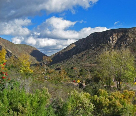
San Diego is perhaps most famous for its incredible access to open space and the abundant recreational opportunities that exist as a result. The geography of the Southern California landscape enriches this reality, as a wide diversity of terrain and a corresponding diversity of opportunities lie within a relatively close distance to heavily-populated and dense metropolitan region. From the beaches that line the Pacific Ocean, one must only travel less than twenty miles to reach a challenging and rewarding hiking destination that represents what Southern California once looked like before it was largely swallowed by suburban development. Mission Trails Regional Park is the remarkable result of land preservation by the city of San Diego. It is one of the largest municipal parks in the United States, and the vast array of terrain that exists within its boundaries offers a wide spectrum of different experiences for its users.
As the sixth-largest municipally owned and operated park in the United States, Mission Trails commands quite a presence on the eastern edge of the city. Part of the reason for the preservation of this land was due to the incredibly varied and steep terrain in which it inhabits. It would have been incredibly difficult for any real wide-scale development to occur over much of the park's territory. However, that has not stopped developers from embarking on projects throughout Southern California in the past. Homes perched on steep hillsides lining deep canyons throughout the region can attest to that. San Diego, though, took the step in 1974 of declaring the entire area a park just as development from the urbanized core of the city continued to march eastward and began to encroach upon the boundaries of the park. Due to this step taken by the city, the highest point in city limits, Cowles Mounatin, is a locally famous public hiking destination. At 1,592 feet, the mountain rises above the park and offers fantastic views of the region. Furthermore, on days where coast and low-lying areas are shrouded in fog and low clouds, the peak is often clear and hikers can marvel in literally being above the clouds.

The park also serves as a model of responsible land use and anti-development in the Southern California region. In 2003, much of the park became engulfed in flames due to the massive and infamous Cedar Fire that spread throughout San Diego County. If homes had been allowed to be built throughout its rugged terrain, there is no doubt that they would have been lost. In many areas marked by similar terrain, the fire devastated the neighborhoods. Dry weather, rugged landscape, drought conditions, and naturally fire-prone vegetation combine to make these areas unsafe for dense human development. Instead, a park was created where everyone can enjoy the varied landscape of the region without encroaching on private property, and the only thing the fire destroyed within its boundaries was vegetation. Unlike homes, they quickly recover and naturally grow back. Mission Trails is a treasure, and an example of a landscape that should be more prevalent throughout the region.
No comments:
Post a Comment