
Mill Ruins Park, which is located in downtown Minneapolis, is an excellent example of open space creation and historic preservation intersecting to create a unique experience that acts as both a local and tourist draw. Located on the shores of the Mississippi River, adjacent to Saint Anthony Falls and its surrounding historic district that features a 1.8 mile walking trails with historical markers located throughout. The Falls were the only natural major waterfall on the Upper Mississippi, until they were replaced in 1869 after a partial collapse by concrete spillway. Later, a series of locks and dams were constructed on the site in the 1950s and 60s. The falls are just one the few unique features that make up the character of the park.
The park is the impressive result of a comprehensive restoration and preservation effort. In the 19th century the site of the park was an area of mills, canals, and other resources that comprised one of the largest direct-drive water-powered facilities in the world. The site harnessed the great power of the falls and the Mississippi to become a leading producer of flour, which was shipped both internationally and nationwide. This area was the catalyst for the incredible amount of industrial development in Minneapolis, which spurred the growth of the city. General Mills, Pillsbury, and Xcel Energy are among the major companies that were founded as direct result of the site. The impetus for growth in downtown Minneapolis was the mills along the site of Mill Ruins Park. However, as the city transitioned its economy over time, the mills eventually became largely abandoned, and many of the historic foundations for the mills and associated buildings were filled in or paved over to make way for newer projects.
The park is the result of an archaeological study undertaken by Saint Anthony Falls Historic District. In 1983, a project was being considered that would have extended West River Parkway through the site of the park. The resulting excavations revealed numerous items of historic interest, including completely intact foundations of both the mills and the original waterpower system. The remains of a railroad roadhouse were also discovered. It was enough of a discovery to prevent the parkway from ever being realized. Over time, the goal changed from preservation for environmental goals to a more historically interpretive reasons. The goal became focused on turning the park into an attraction that would promote economic and cultural development as well as historic tourism.
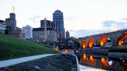
The park is a success in providing a sense of history to the park user. The well-maintained park seems as though it is of a different era, although it is interspersed with thoroughly modern landscaping and walkways. As one descends from the bluffs of downtown to the base of the Mississippi, it is as if they were traveling to another time entirely, a time where architecture was different and industry dominated. Besides the attraction of the ruins, the park also features a magnificent view of the Stone Arch Bridge, which was constructed in 1883 and is directly adjacent to the park. It is a National Historic Landmark and was designed as a crucial link between farmers and the production mills. The parks also features biking and walking paths, as well as raised catwalks.
The park is an inventive re-use of not only abandoned industrial land, but also of historically important land. It is also in the heart of the city, improving the quality of life in a dense area. Minneapolis has a reputation from outsiders of being a city that is very cold and marked by a harsh climate. However, despite that, the city actually has some of the public park and trail infrastructure in America. Mill Ruins Park is an example of how Minneapolis is getting it right in the public land arena.

No comments:
Post a Comment